The importance and beauty of North Sea salt marshes
Ameland, an Island off the coast of the Netherlands, 1999.
I was three years old when we, that is my grandparents and I, visited Ameland for the first time in my life. Back then, sitting on the beach, I was probably more interested in my pink and yellow toy truck with working suspension, than in one of the most fascinating environments on our planet, that lay only about 7 kilometres due east of me – The Salt marshes of the Wadden Sea.
The Wadden Sea, spanning the coasts of the Netherlands, Germany, and Denmark, is an environment of worldwide importance and one that is completely unique, as is the sea itself. The North Sea experiences some of the strongest tidal variations among all continental shelf seas on our planet. With typical tidal ranges between 1.5 and 3 meters, broad flats of the Wadden Sea get completely exposed, making it possible to walk from the mainland to most of the islands in the Wadden Sea.

Like all oceans on Planet Earth, the North Sea faces challenges and is vulnerable to overfishing, industrial plants, harbours, shipping traffic, and most importantly – climate change.
To protect the ecosystem, the Triliterale Wattenmeerzusammenarbeit (TWSC) was established in 1978, followed by the Triliteral Wadden Sea Plan (TWSP), in which binding principles for the protection, conservation, and development of the Wadden Sea were established by the three aforementioned countries. In 2009, the Wadden Sea partly became a UNESCO World Heritage site, acknowledging the importance of its ecological importance and declaring its protection as paramount.
Of course, these measures are often hard to grasp for an individual, as well as the evaluation of their effectiveness. Surely, there are numbers and statistics of the evident successes of the established protections programs – but these are also hard to grasp. No one can simply see and feel a statistic in the real world. On one of our trips to Ameland, I, however, found myself a very personal, and probably very unscientific, indicator for the evaluation of the effectiveness of the protection of the Wadden Sea.
A good six years after my first, very unconscious, visit to the island, my Grandpa and I were riding our bikes on the wadden side of the island, below the dike, specifically the inland side of the dike.
At this point, it is probably appropriate to give an introduction to dikes – Dikes are engineered embankments built to hold back the water of the North Sea. Chances are high that they have sheep grazing on top. On the inland side, right behind the dikes, there are usually small drainage channels or Sloten that crisscross meadows, where cows and horses graze.

They Sloten guide excess water and prevent flooding. Without the protection of dikes, the low-lying land behind the coast would be regularly inundated with water from the ocean, making permanent settlement or agriculture impossible. They also hinder coastal erosion and prevent storm surges from destroying everything behind them.
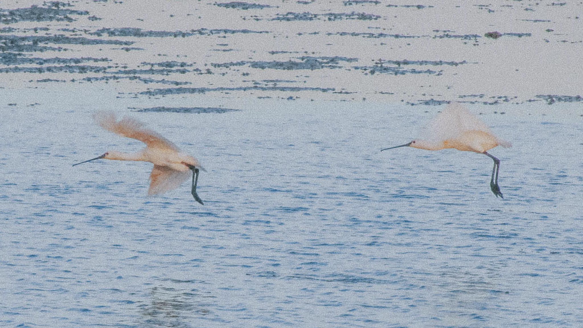
Suddenly, my grandpa stopped his bike, and so did I. He excitedly pulled out his binoculars and gave them to me. A good 40 meters down the road, there was a big white bird, with a black bill that almost looked like a spoon. At first, I didn’t know what was so special about the bird; then my grandpa explained it to me. The bird we had seen was a spoonbill. And even though my grandparents visited Ameland a good 20 times prior to this visit, he’d only seen a spoonbill once before.
In the following years, we started to see them more regularly, and about 20 years later, it’s likely to spot a small group of spoonbills consistently, if you know where to look. Spoonbill populations in the Netherlands were down to around 150 breeding pairs in the late 1960s. But with protection measures in place, their number climbed to 850 breeding pairs in the late 1990s. By 2008, there were already over 1900 pairs, and in the beginning of 2023, there were over 4000, over 2000 of them on the Wadden Islands. An indicator of the effectiveness of the protective measures agreed on in the TWSP, and a very personal one for me.

But it is not the dikes and meadows that are in need of preservation. Even though this environment is beneficial for birds like the spoonbill, it is not enough to support them.
The tides of the North Sea create somewhat of a shift schedule for birds. While there is low tide, oystercatchers, various species of gulls, common shelducks, redshanks, plovers, and dunlins search for mussels and crabs in the mud. When the water comes back, they switch to the meadows and join the greylag geese in the search for worms and snails.

One could think that the dikes and meadows play a pivotal role, not only for humans living on these islands, but also for the birds, and indeed they provide feeding grounds, but most birds and many other animals living on Ameland couldn’t exist with only the tidal flats, dikes, and meadows. The problem with this transition zone is that there is no transition, just an artificial barrier between land and sea. That is not only problematic for the birds, because the human-used meadows leave not enough space for hatching and raising chicks, but it is also problematic for the environment and biodiversity. Dikes, being a vital protection against storm floods, cannot raise the land and keep up with rising sea levels. They also cannot provide a habitat and hatcheries for a multitude of animals, or act as effective carbon sinks, but there is an environment in the Wadden Sea that can.
On the east side of Ameland rises its highest dune and with that its highest peak. The Oerdblinkert is 24 meters tall, and below it lie the salt marshes. There are no dikes in sight, yet the island is still here, not eroded away. Below the Oerdblinkert stretches one of the planet’s most unique environments – the North Sea salt marsh.

Saltmarshes, like dikes, have the power to absorb wave energy and protect the islands from storm floods. By depositing mud and sand, the salt marshes gradually rise, allowing the coast to keep pace with sea-level rise. The downside, at least for human use of the land, is that salt marshes need vast amounts of space and leave the land directly beyond the water’s edge unusable for agriculture, hence why historically they often were claimed for said agriculture and dried up.
A detrimental development for the North Sea ecosystem. Salt marshes take a long time to form and need very specific conditions to develop at all. They can only evolve along shallow, low-current coasts where continuous sediment deposition is possible. These conditions allow sediments to accumulate, raising the mudflat surface and enabling the first plants, such as glasswort (Salicornia), to establish themselves. The temperate climate of central Europe also plays a pivotal role. In the tropics, similar conditions would lead to the formation of mangrove forests.
Around 45 different species of plants grow in salt marshes. These plant species are mostly salt plants or halophytes. Growing in salty conditions is a major challenge for plants.
All plants rely on water and nutrients in order to grow. Therefore, a plant growing in saline conditions needs to have a higher salt concentration than its surroundings. If the external salt concentration is higher, the plant loses water and dies. While keeping their internal salt concentration high is vital, it is also paramount to not let it spike too high, since a too-high internal concentration of salt is toxic to plants. Different species have developed various mechanisms to achieve this. English mudgrass, for example, regulates salt through specialized salt glands. Sea asters store salt in older leaves and shed them when concentrations get too high. Saltmarsh grass filters out salt at the roots using micro-filter structures. Glasswort, the pioneer plant of the salt flats, on the other hand, is one of the only halophytes that actively requires salt for optimal growth. It stores its excess salt in its succulent tissues and older stems, which helps maintain water balance. All these adaptations require a lot of energy, which is why salt marsh plants grow slowly and have a short growing season.

The Marsh itself is divided into three zones.
The pioneer communities closest to the sea are induced by salt water around 700 times a year. Seawater from the North Sea deposits sediments in areas with low water flow. Only pioneer plants like glasswort take advantage of these spots. Their leaves and roots further slow the water and capture more sediment, creating a suitable substrate for plants of the lower salt marsh, like sea aster, sea plantain, and cordgrass. Behind the lower salt marsh, there is usually a small channel, before the terrain shifts into the upper salt marsh, filled with sea lavender, scurvygrass, asters, salt- and cordgrass.
The upper salt marsh also supports a wide variety of animal life. Spoonbills and other ground-nesting birds find shelter and food to raise their chicks. That’s also the reason why, at the end of the Oranje Wandelroute, a path my grandparents took countless times to explore this unique landscape, there is a sign that says Vogelrustgebied, or bird resting area, that prohibits us from going further into the marsh.
But it’s not only birds that call the marsh their home. Even the only big mammals of the Dutch islands, deer, live and thrive in the marsh. In the small water channels that crisscross the marsh, young fish find shelter from predatory fish and are themselves a source of food for terns. Over 1650 insect species call the marshes of the North Sea their home. The magnificent salt beetle digs a burrow up to 10 centimetres deep, in which it stores algae for periods of bad weather. The yellow meadow ant keeps aphids in its flood-protected burrows and feeds on their excreted honeydew, before the aphids become food themselves at the end of spring.

The marsh not only anchors the land and provides a habitat for countless species, but also plays a vital role for the earth’s climate. Salt marshes act as powerful carbon sinks, capturing and long-term storing atmospheric carbon, sometimes more efficiently than forests. In times of rising temperatures and sea-level rise, that makes North Sea salt marshes a vital force in fighting climate change. Even though salt marshes can keep up with sea-level rise, the predicted changes in sea level could overwhelm the natural sedimentation and accretion rate of marshes, meaning they may drown instead of keeping pace. Furthermore, altered rainfall patterns, a higher frequency of ever heavier storms, salinity fluctuations, and heat stress can all affect the delicate ecology of salt marshes and the species that depend on them. These shifts, attributed to climate change, create a global responsibility for change. Only a combined effort of global action and ongoing local protective measures has a chance of preserving the North Sea salt marshes.
I, for myself, very much hope that we as humans pull through in preserving our planet, so maybe one day I can show my grandchildren the beauty of this place beyond the dikes.
Thank you Uta & Eckard for showing me this most beautiful place.
All images and text by Jona-Tristan Köhring